 FAO Map Catalog
UN Food and Agriculture Organization
Type of resources
Available actions
Topics
Keywords
Contact for the resource
Provided by
Representation types
Update frequencies
status
Scale
-

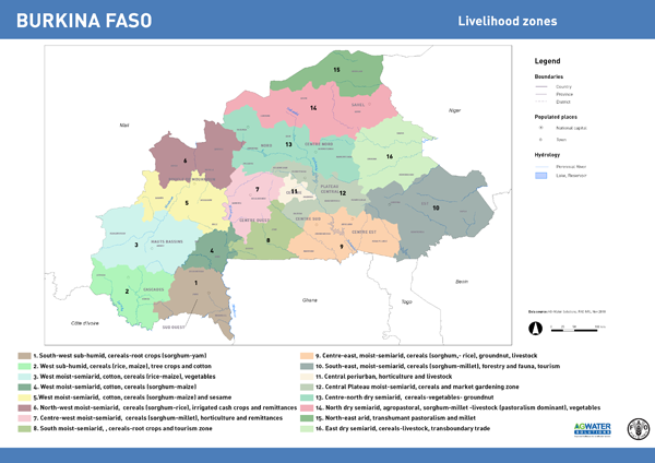
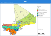
Livelihood zoning consists in identifying areas where rural people share relatively homogeneous living conditions, on the basis of a combination of biophysical and socio-economic determinants. The main criteria to establish livelihood zones are: the predominant source of income (livelihood activities); the natural resources available to people and the way they are used; and the prevailing agroclimatic conditions that influence farming activities. Patterns of livelihood vary from one area to another, based on local factors such as climate, soil or access to markets. The analysis delineates geographical areas within which people share similar livelihood patterns: source of living, access to food, farming practices, including crops, livestock and access to markets. The map of livelihood zones is the main output from a participatory mapping workshop and forms the basis for the overall AWM assessment. It describes and geographically locates the different country livelihood contexts, focusing on the main smallholdersâ livelihood strategies, their water-related problems and other constraints for development, and the role agricultural water management plays for their livelihoods. An attribute table provides a detailed description of each livelihood zone.
-

The study 'Water and the Rural Poor. Interventions for improving livelihoods in Asia' has expanded the concept of FAO-SOLAW âmajor agricultural systemsâ map and conceptual framework as a proxy to characterize and map rural livelihoods in the region, given the strong link between agriculture and livelihoods and the necessity to identify a manageable number of distinct livelihood systems. While such approach is helpful for regional analysis, at national and sub-national scales the range of assets and constraints and the heterogeneity of situations that characterize livelihoods in rural areas go beyond agriculture and encompass off-farm activities. Expert consultations have enabled identification of major livelihood systems in the region that are geographically located by reclassifying the agricultural systems map and including additional criteria and mapping layers. Specifically, the livelihood systems are based mainly on the following biophysical and socio-economic criteria: ⢠Land cover and land use; ⢠Agricultural water management and use; ⢠Climate; ⢠Topography; ⢠Dominant crops; and ⢠Population density.
-
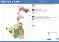
Livelihood zoning consists in identifying areas where rural people share relatively homogeneous living conditions, on the basis of a combination of biophysical and socio-economic determinants. The main criteria to establish livelihood zones are: the predominant source of income (livelihood activities); the natural resources available to people and the way they are used; and the prevailing agroclimatic conditions that influence farming activities. Patterns of livelihood vary from one area to another, based on local factors such as climate, soil or access to markets. The analysis delineates geographical areas within which people share similar livelihood patterns: source of living, access to food, farming practices, including crops, livestock and access to markets. The map of livelihood zones is the main output from a participatory mapping workshop and forms the basis for the overall AWM assessment. It describes and geographically locates the different country livelihood contexts, focusing on the main smallholders’ livelihood strategies, their water-related problems and other constraints for development, and the role agricultural water management plays for their livelihoods. An attribute table provides a detailed description of each livelihood zone.
-
Livelihood zoning consists in identifying areas where rural people share relatively homogeneous living conditions, on the basis of a combination of biophysical and socio-economic determinants. The main criteria to establish livelihood zones are: the predominant source of income (livelihood activities); the natural resources available to people and the way they are used; and the prevailing agroclimatic conditions that influence farming activities. Patterns of livelihood vary from one area to another, based on local factors such as climate, soil or access to markets. The analysis delineates geographical areas within which people share similar livelihood patterns: source of living, access to food, farming practices, including crops, livestock and access to markets. The map of livelihood zones is the main output from a participatory mapping workshop and forms the basis for the overall AWM assessment. It describes and geographically locates the different country livelihood contexts, focusing on the main smallholdersâ livelihood strategies, their water-related problems and other constraints for development, and the role agricultural water management plays for their livelihoods. An attribute table provides a detailed description of each livelihood zone.
-
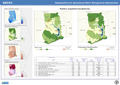
Broad typologies of irrigation systems in project countries were identified by analyzing distribution of area equipped for irrigation in relation to climatic conditions, (proximity to) water resources and coastline, and dominant land cover. The distribution of irrigation systems is derived from the Global Map of Irrigation Areas input files, but caution is needed as not all information is validated or updated. It is foreseen that the country level analysis will better refine this preliminary review. The land cover (FAO, 2014) input can help identifying valley bottom and wetlands where water is managed under no or partial control, most commonly found in humid and sub-humid climates. Proximity to (perennial) rivers and water bodies give an indication on whether the irrigation area is serviced by surface or groundwater, although caution is needed at this scale, as reliable information on irrigation infrastructures is not consistently available. Proximity to coastline and deltas are used to characterize irrigation areas which rely on coastal aquifers.
-
This map shows areas suitable for the Agricultural Water Management interventions as identified by the project. The assessment is based primarily on each intervention's bio-physical requirements (such as: climate, proximity to water resources, terrain), but it also includes a qualitative rating based on socio-economic settings (namely distance to markets).
-
Livelihood zoning consists in identifying areas where rural people share relatively homogeneous living conditions, on the basis of a combination of biophysical and socio-economic determinants. The main criteria to establish livelihood zones are: the predominant source of income (livelihood activities); the natural resources available to people and the way they are used; and the prevailing agroclimatic conditions that influence farming activities. Patterns of livelihood vary from one area to another, based on local factors such as climate, soil or access to markets. The analysis delineates geographical areas within which people share similar livelihood patterns: source of living, access to food, farming practices, including crops, livestock and access to markets. The map of livelihood zones is the main output from a participatory mapping workshop and forms the basis for the overall AWM assessment. It describes and geographically locates the different country livelihood contexts, focusing on the main smallholdersâ livelihood strategies, their water-related problems and other constraints for development, and the role agricultural water management plays for their livelihoods. An attribute table provides a detailed description of each livelihood zone.
-
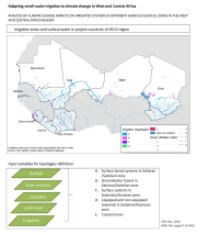
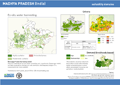
This map shows where AWM can be the entry point for improving livelihoods and where to prioritize investments in AWM to have the maximum impact on rural livelihoods. High potential areas are those showing the highest potential for AWM investment. These areas are identified on the basis of three guiding principles: 1) where water is available 2) where the target beneficiaries are mostly located; and 3) where water is key for livelihoods.